We have specialized in the development of fast, portable and (platform-)independent solutions for graphical information systems (GIS). All our solutions are developed in-house. This gives us a clear competitive edge and ensures total flexibility in all future developments - tailored to individual clients' demands.
Consequently, our clients are able to offer profitable added-value services with little effort in a minimum of time! - Online Wireless Maps: personalized information is available anytime and anywhere (in-time traffic information, links with hotel reservation systems, booking-systems for concert tickets etc.)
- Independent of source formats, platforms, target devices and data structures: a consistent solution for all requirements
- By means of an efficient implementation and realization of our extendable systems, a variety of different services can be offered quickly
- Existing structures are being used and actually enriched by using powerful mobile applications, irrespective of already existing systems and data
- Data is always up-to-date, paving the way for profitable applications e.g. in the fields of telematics and location-based services
- The possibility of individual enhancements allows for the efficient realization of clients' wishes
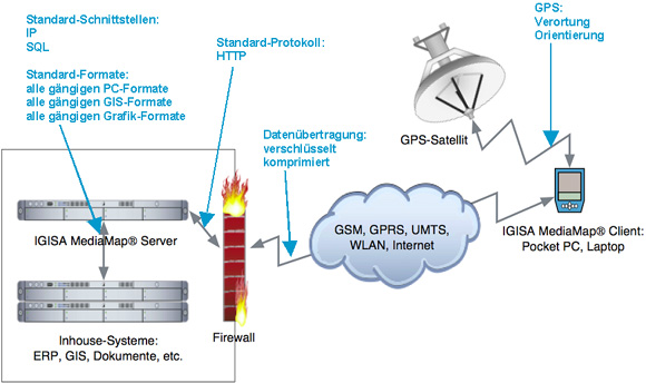
1. Igisa MediaMap® - Innovation in telematics Our client-server-structure is a highly flexible system, allowing the fast implementation of versatile services. MediaMap® is capable of visualizing graphical data from a multitude of different sources.
Vector-based information (dxf, dwg, mif, mid, shp, e00, dgn etc.) as well as raster-data (bmp, jpeg, tiff, gif, img etc.) can be combined in this hybrid system in any desired way (for example city maps combined with aerial photography). The content-database in the background provides the user with all relevant pieces of information.
Benefits at a glance: - High data compression by means of different CoDec-algorithms - optimized for being used with mobile devices
- Open interfaces allow the integration of different systems (like Access, Oracle, SQL, Delphi to name but a few) und ensure a high degree of compatibility
- MediaMap® can be integrated into any application that supports ActiveX
- Works also without plug-ins using standard browser-functionality
- The software architecture can be used on different platforms, ranging from the PC to mobile PDAs, from Linux to Windows
- Access to all internet services (e-Mail, WWW, etc.)
- Integration of individual content ("mobile channels")
- The dynamic visualization of the users' current position (via GPS or other localization technologies) allows for smart location-based-services
- Data from all kinds of sources can be integrated (weather, hotels, stock information etc.)
- Images can be viewed in all sizes, at all zoom-levels
- The data can be stored locally on the client
- Multidirectional geographical communication with different mobile users
- Easy-to-use viewing-software
2. MediaMap® Mobile - Foundation for efficient Location Based Services Graphical data - like cartographical information, E-Documents, picture archives
- are compressed at the server and decompressed on the client after transmission. Hence the relevant data is held locally and all desired operations (zoom, pan
) can be conducted immediately. Through processing with additional data over a Geographical Intermediate Layer supplementary information to the specific parts of the pictorial data can be displayed. The main advantages - available as stand-alone-application or plug-in
- small size of the application
- high compression possibility (up to the tenfold reduction of the file size compared to jpeg-algorithms)
- Position tracking (GPS)
- display and editing functions
- user friendly tools
The solution provides further intelligence at the clientside when utilized for Location Based Services. While the own position is indicated dynamically the client verifies that the currently active maps (part of the map, chosen resolution) are held locally and updates the information from the server autonomous so the user never "leaves" the map.
The data can be stored in compressed form on the server or be generated on the fly (especially useful for dynamic content included within HTML-documents). So an accelerated transfer of web-contents is possible. 
|